

This article was first published on geektime.es. Translation by Frances Jenner.
Over the last couple of months, Google Maps has surprised the world with new features which make using the application easier than ever. The most recent looks to raise citizens’ awareness of environmental conditions in cities by showing the levels of greenhouse gases and promoting the use of renewable energies, and Buenos Aires is one of the first cities to be a part of this exciting new initiative.
Inhabitants of large cities that are plagued with heavy traffic live alongside pollution every day, although often it is difficult to notice when in the centre of these bustling metropolises. In Latin America, Santa Gertrudes in Brazil, Lima in Peru and La Paz in Bolivia are the cities with the worst levels of air pollution with 95, 88 and 82 micrograms of pollutant per square metre respectively. The World Health Organisation’s limit for healthy air is placed at a mere 50 micrograms/m3.
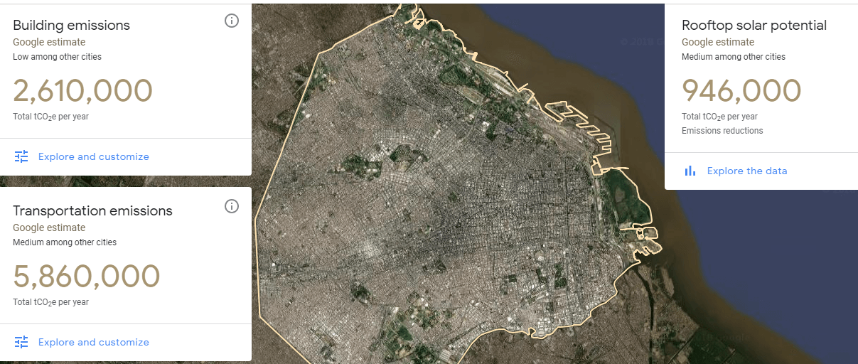
In order to better understand the areas where this pollution accumulates and the levels to which it rises, there are various websites that offer detailed information of current air pollution levels. However, Google Maps has announced its own tool called Environmental Insights Explorer that allows users to track their city’s contamination levels in real time.
The new feature uses aerial photographs from all the cities in the world and calculates each one’s carbon footprint. This way, it can not only track pollutant information but also give city officials the data they need to improve the city’s air quality.
“This is looking at the thousands of cities that are out there today that don’t typically have the resources to spend on digging up or analyzing the data,” Nicole Lombardo, who leads partnerships for Google’s environmental insights team, told The Fast Company. “This tool helps to do some of that and reduce some of the complexities and the cost in the process, so you have more people spending less time data-gathering and data-crunching and more on the action planning.”
“For now, taking action on climate change can’t wait, so we hope to accelerate the move from measurement to action.” Google Insights Initiative.
Released in Beta mode on Sept. 10, the application currently has five example cities: Victoria in Canada, Melbourne in Australia, Pittsburgh and Mountain View in the United States, and Buenos Aires, Argentina.
Environmental Insights Explorer can differentiate between residential homes and business areas and calculates the amount of energy they use and the emissions of each region. Google also collaborates with the cities being analysed in elaborating a study of the effects of greenhouse gases across the globe.
Finally, another characteristic that is involved in this new tool will be Project Sunroof, with which Google analyses the form of the houses using satellite images, along with the environmental conditions of the area, creating a report which provides information of which areas or houses have optimum solar energy potential for the user.
The new tool hopes to expand across the globe, increasing accuracy, promoting the use of renewable energies and raising awareness of the issue of climate change across the globe in individuals and government officials who can take the steps needed to prevent it.